March 22, 2016
Kiwa Glacier Retreat, British Columbia 1986-2015
Posted by Mauri Pelto
Kiwa Glacier retreat from 1986 to 2015 in Landsat images. Red arrow is 1986 terminus and yellow arrow 2015 terminus location. Purple arrow indicates upglacier thinning where more bedrock is exposed. Purple dots indicate the transient snowline
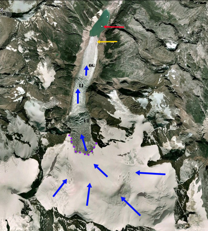
Kiwa Glacier is the longest glacier, at 9 km, in the Cariboo Mountains of British Columbia. The glacier drains northwest from Mount Sir Wilfred Laurier and is near the headwaters of the Fraser River, where it terminates in an expanding lake at 1465 m. Here we examine glacier change from 1986 to 2015. In 1986 the glacier terminated in the 700-800 m long proglacial lake. The glacier has two significant icefalls above the terminus at 2300 m and 1800 m. The lower icefall generating a series of ogives that are generated annually due to seasonal velocity fluctuations. The ogives indicate the glacier velocity below this icefall. There are 20 ogives in the span of approximately 1 km indicating a velocity of 50 m/year. In 2015 the glacier still terminates in the proglacial lake that is now 1400-1500 m long indicating a retreat of 700 m in the thirty years from 1986-2015. The lower 300 m of the glacier is nearly flat suggesting the lake will extend at least that far, note 2010 image from Reiner Thoni, Canadian Mountaineer. This is also the extent that will be lost relatively quickly via iceberg calving and continued surface melt. Above this point flow remains vigorous and retreat could diminish. Upglacier thinning has expanded bedrock areas even separating sections of the glacier, purple arrows. The transient snowline in mid-August in the Landsat images is at 2550 m. Driving through the area last week, the snowline is at 1000 m, quite high for mid-March.
Beedle et al (2015) note that glaciers in the Cariboo Mountains were close to equilibrium from 1952 to 1985 : 9 glaciers advanced, 12 receded, and 11 did not change. After 1985 they noted that all glacier retreated in the Cariboo Mountains. The response time of the glaciers to climate change is the main cause for the differing response of individual glaciers in the region as has been noted in other Pacific Northwest regions (Pelto and Hedlund, 2001 & Tennant et al, 2012). Response times are faster for glaciers with steeper slopes, higher velocity/length ratios and a higher ratio of accumulation-ablation/ ice thickness. The decline of glaciers, warm weather and reduced snowpack combined in 2015 to place a stress of Fraser River salmon due to lower discharge and higher temperature. This could be an issue in 2016 as well.
Kiwa Glacier in 2004 Google Earth image
2010 Image from Reiner Thoni. Well defined trimlines above the lake. Note flat lower section of the glacier.


 Dean of Academic Affairs at Nichols College and Professor of Environmental Science at Nichols College in Massachusetts since 1989. Glaciologist directing the North Cascade Glacier Climate Project since 1984. This project monitors the mass balance and behavior of more glaciers than any other in North America.
[…] zone. The retreat shouldn’t be as substantial as many glaciers within the area, be aware Kiwa Glacier or Franklin Glacier, however the total adjustments are […]