
March 10, 2016
Lago Onelli, Argentina trio of Glaciers Retreat and Separate
Posted by Mauri Pelto
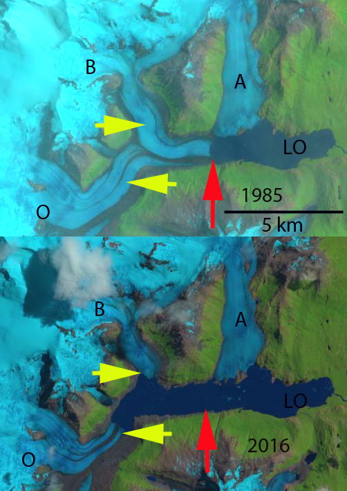
Onelli Glacier (O), Belados Glacier (B) and Agassiz Glacier (A) compared in Landsat images from 1985 to 2016. The red arrow indicates the 1985 terminus location and yellow arrow is the 2016 terminus location.
The Onelli Glacier drains eastward from the South Patagonia Icefield (SPI) into Lago Onelli (LO), which then connects to Lago Argentino. Lago Onelli has three main glaciers terminating in the lake Agassiz (A), Onelli(O) and Bolados Glacier (B). Onelli glacier is noted as 13 km long with an area of 84 square kilometers by the Labratorio de Glaciologia in Chile . Davies et al (2012) noted that the most rapid period of retreat since 1890 for Bolado and Onelli Glacier was from 1986-2001. Warren and Sugden (1993) note an 1800 meter retreat from 1945-1992 for Onelli Glacier and 850 meters for Agassiz Glacier. Eric Shipton was the first to visit this glacier and did so in the company of Ohio State glaciologist John Mercer in 1958. They found Lago Onelli so filled with icebergs that little water could be seen (Shipton, Land of Tempest, 1963). Agassiz and Onelli Glacier were observed to have a shared terminus in 1958 much like Onelli Glacier and Belados Glacier in 1985.
A comparison of Landsat satellite images indicate the separation and retreat of Bolados (B) and Onelli Glacier (O) from 1985-2016. In 1985 the joint terminus cuts directly across Lago Onelli as one reasonably straight 1.6 km wide calving front just short of connecting with Agassiz Glacier. By 2004 the glacier had retreated 3000 m and Belados and Onelli were barely touching.The combined termini width was 1.8 km. By 2010 the glaciers were separated by 1300 meters. By 2016 Belados Glacier has retreated 3500 m from 1985-2016 and Onelli Glacier has retreated 3800 m. The glaciers in 2016 are separated from each other by 1800 m. The ELA in the satellite images from recent years has been 1300 meters. Agassiz Glacier has retreated 400 m during the 1985-2016 period. The glacier is grounded on three islands that acts as pinning points, reducing calving losses and the retreat rate.
Willis et al (2012) examined the mass change of the 12,100 km2 SPI from 2000-2012: in the accumulation zone the average thickness change of −1.1 ± 0.1 m/year, for the ablation zone the average thickness change is −3.5 ± 0.02 m/year. This widespread loss even in the accumulation zone indicates that retreat will continue. A comparison of Landsat images from 1998 to 2013 indicates upglacier thinning at the purple arrows. Schaefer et al (2015) noted that the mass loss of SPI has been largely from increased calving losses. Mouginot and Rignot (2015) observed that Onelli Glacier does not have a high velocity reach extending beyond the immediate terminus zone, unlike major outlet glaciers of the SPI.

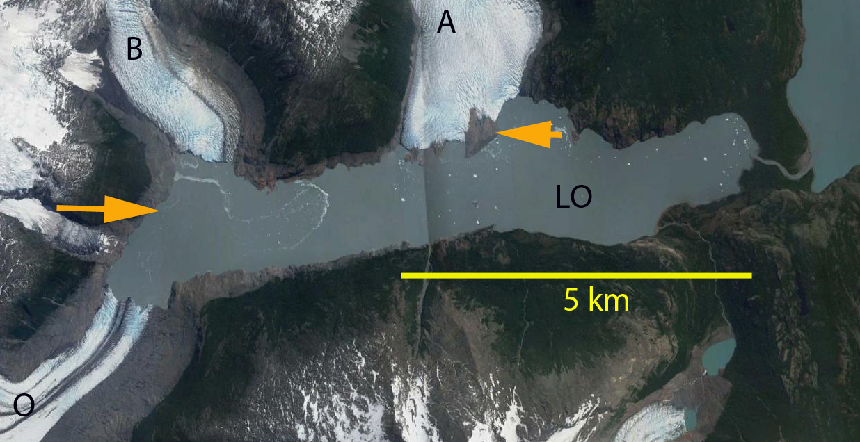
Google Earth image of Onelli Glacier and Belados Glacier in 2004 above and 2015 below. Orange arrow indicates the 2004 terminus location.
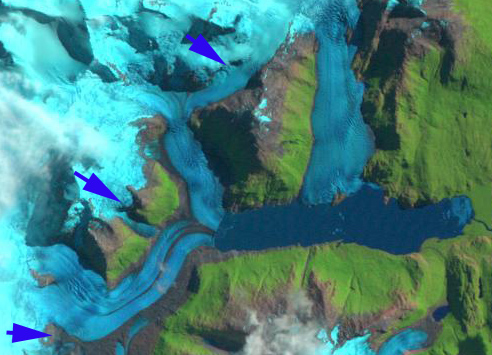
Landsat images from 1998 and 2013 indicating specific areas of upglacier thinning at the purple arrows.
 Dean of Academic Affairs at Nichols College and Professor of Environmental Science at Nichols College in Massachusetts since 1989. Glaciologist directing the North Cascade Glacier Climate Project since 1984. This project monitors the mass balance and behavior of more glaciers than any other in North America.