
January 21, 2016
Balmaceda Glacier Retreat, Chile Releases Island
Posted by Mauri Pelto
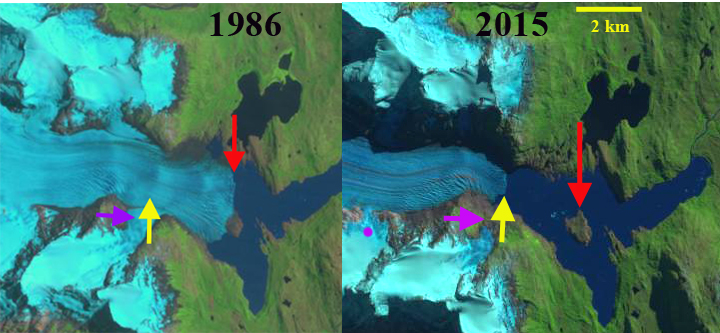
1986 and 2015 Landsat images of the Balmaceda Glacier, Chile region. Red arrow indicates 1986 ice front, yellow arrow 2015 ice front and purple arrow a tributary that has detached.
Balmaceda Glacier (Felicia Glacier) is at the southeastern end of the Southern Patagonia Ice Cap (SPI) field and drains into the Serrano River. There is another glacier referred to as Balmaceda that descends steeply almost to the shores of Fiordo Ultima Esperanza, hence Felicia Glacier will be used here. Willis et al (2012) observed that between February 2000 and March 2012, indicate that SPI is rapidly losing volume, that thinning extends to the highest elevations. The mass balance loss is occurring at a rate of −20.0 ± Gt/year, which is +0.055 mm/year of sea level rise. The retreat is driven by increasing calving rates from the 1975-2000 to the 2000-10 period (Schaefer et al, 2015). The pattern of retreat is consistent between these glaciers and the region as noted by Davies and Glasser (2012), annual rates of shrinkage in the Patagonian Andes increased in from 0.10% year from 1870-1986, 0.14% year from 1986-2001, and 0.22% year from 2001-2011. These losses have led to retreat such as at Glaciar Marconi and Glacier Onelli
In 1986 the glacier terminated on an island in that acts as pinning point stabilizing the glacier front. The calving front is over 2.5 km wide. By 2000 Landsat imagery indicates the glacier has retreated from the island with the greatest retreat on the north side. By 2013 the glacier has receded into a narrow western arm of the lake, the snowline is at 600 m. By 2015 a southern tributary has separated from the main glacier at the purple arrow. The terminus at the yellow arrow is 1 km from an increase in surface slope indicating a rise in bedrock that may be the inland margin of the lake. The retreat from 1986 to 2015 is 2100 m and the current calving front is 1.2 km wide. The snowline in 2015 is at 1000 m is quite high. De Angelis (2014) notes the ELA for this glacier at 690 m. Above the snowline the linear wind sculpted features oriented west to east indicate the ferocious winds of the region Schaefer et al (2015) note the exceptional accumulation rates in the region
The Balmaceda Glacier drains into the Serrano River, the headwaters being Del Toro Lake on the southern boundary of Torres del Paine National Park. The river is home to numerous giant Chinook salmon which can weigh up to 35 kg with fishing season from June to December. Chinook salmon have just recently started populating rivers in Chile and Argentina. Fish hatcheries in southern Chile release thousands of Chinook smolts. The introduced Chinook originate from tributaries of the Columbia River of Washington and Oregon.

2000 Landsat Image
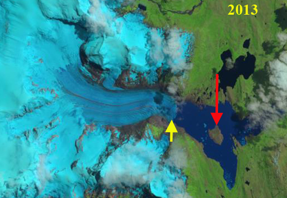
2013 landsat image
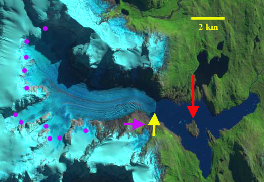
2015 Landsat image the purple dots are the snowline which at 1100 m is quite high. Also note the long wind drift features extending west to east above the snowline.
 Dean of Academic Affairs at Nichols College and Professor of Environmental Science at Nichols College in Massachusetts since 1989. Glaciologist directing the North Cascade Glacier Climate Project since 1984. This project monitors the mass balance and behavior of more glaciers than any other in North America.