
January 11, 2016
Hooker Glacier Retreat, 1990-2015
Posted by Mauri Pelto
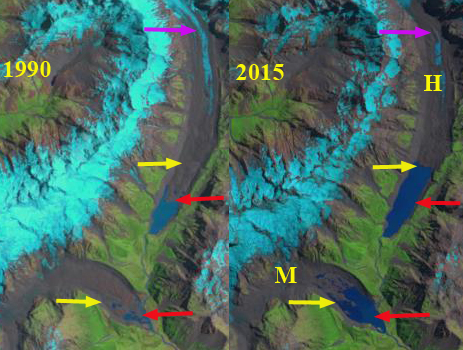
Glacier change revealed in Landsat images from 1990 and 2015. Mueller Glacier (M) and Hooker Glacier (H). The red arrow indicates 1990 terminus location, the yellow arrow indicates 2015 terminus location and the purple arrow indicates upglacier thinning.
Hooker Glacier parallels the Tasman Glacier one valley to the west draining south from Mount Hicks and Mount Cook. Hooker Glacier is a low gradient which helps reduce its overall velocity and a debris covered ablation zone reducing ablation, both factors increasing response time to climate change (Quincey and Glasser 2009). Hooker Lake which the glacier ends in began to from around 1982 (Kirkbride, 1993). In 1990 the lake was 1100 m long (Figure 11.2). From 1990 to 2015 the lake expanded to 2300 m, with the retreat enhanced by calving. The 1200 m retreat was faster during the earlier part of this period (Robertson et al.,2013).

Map of the region in 1972 indicating the lack of proglacial lakes at the end of Mueller, Hooker and Tasman Glacier.
The lower 3.4 km of the glacier has limited motion. Robertson et al, (2012) suggest the retreat will end after a further retreat of 700-1000 m as calving will decline as the lake depth declines. The peak lake depth is over 130 m, with the terminus moving into shallow water after 2006 leading to declining retreat rates (Robertson et al (2012).Gjermundsen et al (2011) examined the change in glacier area in the central Southern Alps and found a 17% reduction in area mainly from reductions of large valley glaciers such as Hooker Glacier. Based on the nearly stagnant nature of the lower glacier and the diminished ice flow from above indicated by debris cover expansion at the purple arrow, it seems likely the retreat will continue well beyond the end of the lake but at a diminished rate.
Hooker Glacier drains into Lake Pukaki,a along with Murchison, Mueller and Tasman Glacier, where water level has been raised 9 m for hydropower purposes. Water from Lake Pukaki is sent through a canal into the Lake Ohau watershed and then through six hydropower plants of the Waitaki hydro scheme: Ohau A, B and C. Benmore, Aviemore and Waitaki with a combined output of 1340 MW. Meridian owns and operates all six hydro stations located from Lake Pūkaki to Waitaki. Reductions in glacier area in the watershed will lead to reduced summer runoff into the Lake Pukaki system (see image below)

Comparison of Hooker Glacier terminus area in 2006 (red arrow) and 2013 (yellow arrow) in Google Earth. Blue arrow indicates icebergs in 2006.

Hydropower projects below Lake Pukaki
 Dean of Academic Affairs at Nichols College and Professor of Environmental Science at Nichols College in Massachusetts since 1989. Glaciologist directing the North Cascade Glacier Climate Project since 1984. This project monitors the mass balance and behavior of more glaciers than any other in North America.
The geographical setting and shape of Hooker lake looks like Imja lake and its surrounding in Everest region of Nepal, Which is also changing its area, volume with very high rate. There was not lake before 1950s, and now it is more than 2 km long LAKE with 75 million cubic meter of water. It is noted that the depth of the lake increased by more than 33 m within 2 years from 2012 to 2014. Similarly, more than 10 million cubic meter of water is increased within those two years.
You are correct, Imja is the most famous, and there are so many other analogs from the Himalaya including Lhonak Glacier, Sikkim
[…] we look back to the 1972 Mount Cook map, see below, no lakes are evident at the terminus of Hooker (H), Mueller (M), Tasman Glacier (T), or Murchison Glacier that all drain into Lake Pukaki, pink […]