
July 23, 2015
Artesonraju Glacier, Peru Retreat & Lake Development
Posted by Mauri Pelto
Artesonraju Glacier is a 3.3 km long glacier in the Cordillera Blanca of Peru drains west from Nevado Artesonraju. It is fed by steep heavily crevassed slopes. The glacier feeds both Lake Artesonraju, a new lake that formed after 1930 and Lago Paron. The two lakes are dammed by glacier moraines and together have posed a hazard of a glacier dammed lake outburst. In 1951 an outburst of water and alluvium traveled from the upper Artesonraju Lake into Lago Paron, raising the water level in Paron causing downstream flooding and concern about the strength of its moraine dam. Mass balance is measured on this glacier annually and reported to the World Glacier Monitoring Service. The glacier lost 0.4 m thickness in 2012 and 2013.
Google Earth Image 2003 of Artesonraju Glacier

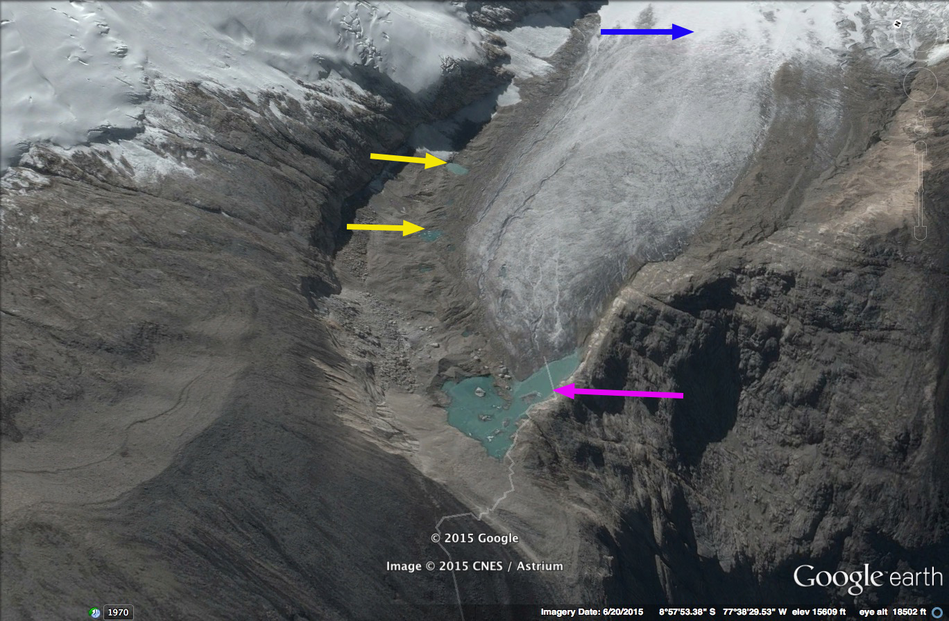
Lago Paron Watershed 2015
There are numerous moraine dammed lakes in Peru, the dams are just comprised of gravel, sand and clay dumped by the glacier. High water levels caused by upstream floods, avalanches or landslides can cause failure of these moraine dams and down stream flood damage prompted the Peruvian government to develop a strategy to address the problem. They began by building tunnels concrete pipes, through the moraine to allow drainage to a safe level, they then rebuilt the moraine over the drainage system and strengthened it. Since development these systems have worked preventing serious flood issues from the lakes.
 ,
,
At Lago Paron a hydropower project has been built that is fed by the tunnel drainage system and Lago Paron has been partially drained to service the hydropower facilities needs. The hydropower faility is owned by Egenor, owned largely by Duke Energy. The lake level has declined substantially by 2003 as the trimline indicates in the image above. This had led to a battle over water resources with local farmers. This Artesonraju Glacier that is the principal feeder to the two lakes retreated 1140 meters from 1932-1987 and by 2003 had retreated another 200 meters. From 2003 to 2015 the glacier continued to retreat 160 meters and the terminus to narrow. An expanding lake at the terminus is evident in the Google Earth images of 2003 and 2015, pink arrow. A pair of melt ponds have also formed on the glacier margin at the yellow arrow as the glacier thinned. In the 2013 Landsat image the terminus has further narrowed and the new lake at the terminus is evident. This is 30% of its length gone in the last 75 years.The lower section of the glacier is flat, uncrevassed and is continuing to thin and melt. Chisholm et al 2014 observed glacier thickness of 20 m near the terminus to a maximum of 160 m, with the potential for the new lake to expand and be 60-80 m deep. The upper reaches of the glacier are heavily crevassed indicating continued vigorous flow fed by healthy accumulation on the flanks of Nevado Artesonraju and Nevado Piramide. The equilibrium line of this glacier is at 5150 m, according to investigations by the Tropical Glaciology Group, Innsbruck, Austria and Hydrology Resources and Glaciology group in Huarez, Peru. They also noted in 2005, that the surface on many parts of the flat tongue had significant sublimation when short wave radiation is limited, and short wave radiation dominates melting during the day. Sublimation occurs when the air is dry and represents a less efficient means of ablating a glacier.
A book by Mark Carey, In the Shadow of Melting Glaciers, examines the history of the impact of these glaciers on Andes towns in the Cordillera Blanca.

2003 Google Earth image
2015 Google Earth image

2013 Landsat Image
 Dean of Academic Affairs at Nichols College and Professor of Environmental Science at Nichols College in Massachusetts since 1989. Glaciologist directing the North Cascade Glacier Climate Project since 1984. This project monitors the mass balance and behavior of more glaciers than any other in North America.