
July 7, 2015
Otemma Glacier Retreat & Snowline Rise, Switzerland
Posted by Mauri Pelto
Otemma Glacier is in the Upper Rhone River watershed and feeds Lac de Mauvoisin. Climate change is altering this glacier, with terminus change not being the main story it is the rising snowline and separation from tributaries. The lake fed by the glacier is impounded by Mauvoisin Dam one of the 10 largest concrete arch dams in the world. The reservoir can store 200 million cubic meters of water. The dam provides hydropower and protection against natural hazard. In 1818, an advance of the Gietro Glacier, now retreated high above the reservoir, generated ice avalanches which blocked the flow of the river. When the ice barrier was breached, 20 million cubic meters of flood water was released devastating the valley (Collins, 1991).There are several other large glaciers in the basin Gietro, Mont Durand and Brenay that provide runoff to power what is today a large hydropower project. The Mauvoisin Dam can produce 363 MW of power.
Otemma Glacier is one of the glaciers where the terminus is monitored annually by the Swiss Glacier Monitoring Network (SCNAT). Here we examine changes in this glacier from 1985 to 2014 including changes in the terminus, snowline elevation and tributary connection during this period using Landsat Imagery. SCNAT reports that the glacier retreated at a rate of 27 m/year from 1985-1999, to 40 m/year from 2000-2014.

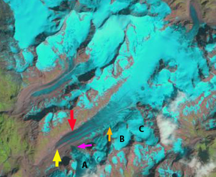
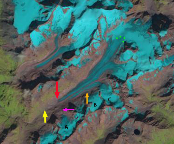
Google Earth view of the glacier indicating glacier flow direction.
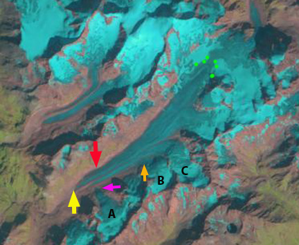
In 1985 the glacier terminates at the yellow arrow, with tributaries A,B & C all joining the main glacier. The snowline is at 2800 m, green dots. In 1988 the snowline extends to the divide with Bas Glacier d’Arolla at 3050 m. In 1999 the snowline also extends to the divide with Glacier d’Arolla. Tributary A no longer connects to the glacier, pink arrow, and the terminus has retreated 300 m.
By 2013 Tributary B is also detached from the main glacier (orange arrow). The terminus has retreated to the red arrow a distance of 1010 m over the thirty year period. The snowline in 2013 and 2014 almost reaches the divide with Bas Glacier d’Arolla with a few weeks left in the ablation season. The area of persistent snowcover is thus restricted to the region above 3050 m. This region is not large as the Bas Glacier d’Arolla captures most of the upper basin. That the snowline is consistently reaching the highest divide for this large glacier is noteworthy. The retreat of the large valley tongue of Otemma Glacier will remain rapid given the consistent high snowlines indicative of limited retained accumulation. Even with current climate not much of the Otemma Glacier can survive. The rising snowline is observed on most glaciers including nearby Rutor Glacier, Italy.
1985 Landsat Image
1988 Landsat Image
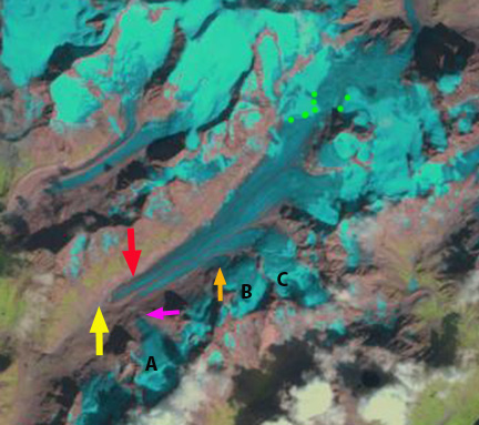
1999 Landsat Image
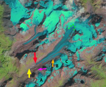
2013 Landsat Image
2014 Landsat Image
 Dean of Academic Affairs at Nichols College and Professor of Environmental Science at Nichols College in Massachusetts since 1989. Glaciologist directing the North Cascade Glacier Climate Project since 1984. This project monitors the mass balance and behavior of more glaciers than any other in North America.