
April 13, 2015
Menlung Glacier Rapid Retreat & Lake Expansion, Tibet, China 1992-2014
Posted by Mauri Pelto
Menlung Glacier is one valley north of the China/Tibet border with Nepal and on the south side of Menlungste Peak. Menlung Glacier has a glacier lake at its terminus that is dammed by the glacier’s moraine. The glacier began to withdraw from the moraine and the lake began to develop after the 1951 expedition to the area. The glacier lake is at 5050 meters, the glacier descends from 7000 meters with the snowline recently around 5500 meters. The lower section of the glacier is heavily debris covered, which when the debris is more than several centimeters thick as in most areas here, reduces the rate of glacier melt. Melt is highest around the supraglacial lakes (shallow lakes on glacier surface), which can lead to the lakes expanding and coalescing. Benn (2001) examined the process on nearby Ngozumpa Glacier, Nepal. This region has experienced significant mass loss of -0.25 m/year from 2000-2010 (Gardelle et al, 2013). The Japanese Aerospace Exploration Agency has a side by side 1996 and 2007 satellite imagery that indicates the Menlung Glacier Lake developing in 1996 that still has remnant glacier ice in it, that is melted by 2007. Here we use Landsat imagery and Google Earth imagery to identify the changes from 1992-2014.
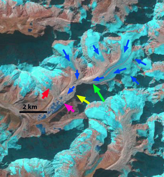
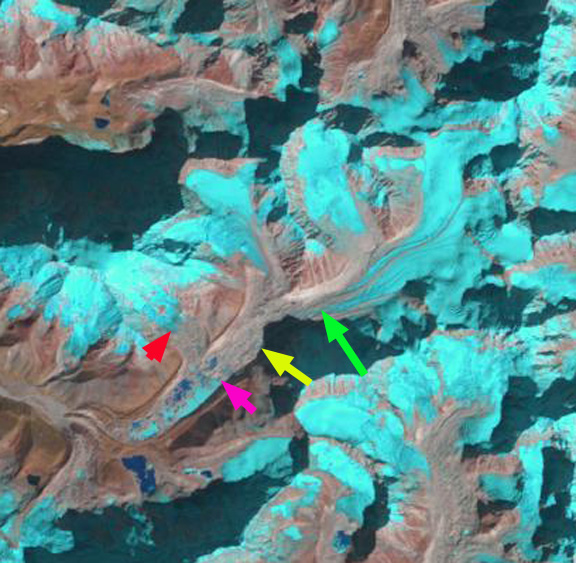
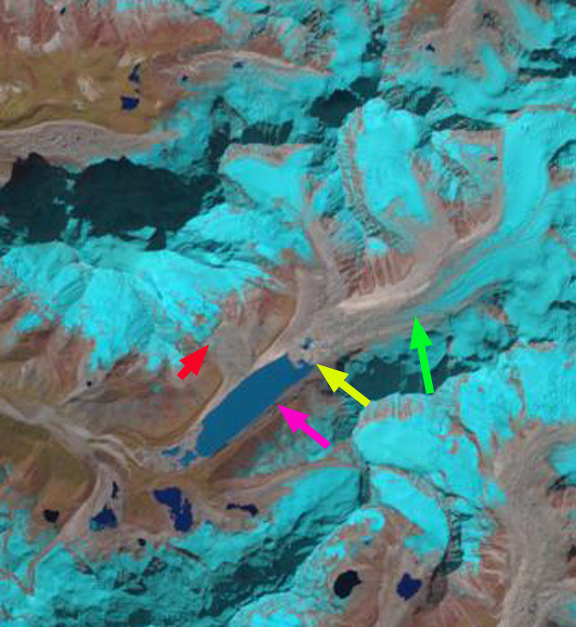
1992 Landsat image: In each image the pink arrow is the 1992 terminus, the yellow arrow the 2014 terminus, the green arrow the furthest downglacier extend of clean glacier ice and the red arrow the lower margin of a tributary glacier in 2014.
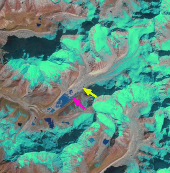
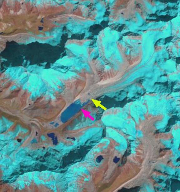
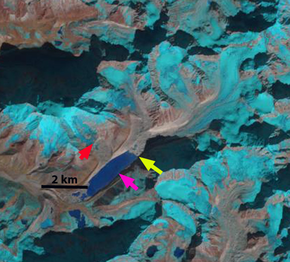
In Landsat imagery from 1992 the lake is still developing from a system of supraglacial lakes interspersed with debris covered stagnant glacier sections. In 1994 there is little change, other than some of the lakes are frozen. In 2001 a contiguous lake has formed that is 500 m long and 600 m wide, though the main glacier front has changed little. The lake rapidly expanded to a length of 1900 meters by 2009. The glacier retreat is 500 meters, the other 300 meters of lake expansion is a continued growth at the moraine end of the lake as ice cored moraine continues to melt. By 2013 the lake has extended to a length of 2250 m, due solely to further glacier retreat. In 2014 has experienced a further 50-100 m of retreat from 2013. The lake is now 2300 m long, and is turning a darker blue color as the amount of glacier flour in it diminishes. A comparison of the terminus and lake using Google Earth images from 2005 and 2014 indicate the rapid lake growth in the last decade. The lower portion of the glacier remains debris covered, and appears stagnant, but has significant supraglacial lakes only with 400 meters of the 2014 terminus, suggesting the period of rapid retreat is nearly over. The region above the terminus in 2014 is dissected by a significant surface glacier stream that extends 2.5 km upglacier to the beginning of the first sections of debris free ice. That the river stays on the surface so long indicates the lack of crevassing and the stagnant nature of the ice. From 1992 to 2014 the area of clean glacier ice has also migrated 1 km upglacier, green arrows. The red arrows indicate a smaller glacier that has retreated further from the lake and has developed some substantial bedrock areas amidst the lower glacier between 1992 and 2014. The retreat and lake expansion parallels that seen at Longbasba, Reqiang, Sepu Kangri and Ngozumpa Glacier.
1994 Landsat image
2001 Landsat image
2009 Landsat image
2013 Landsat image
2014 Landsat image
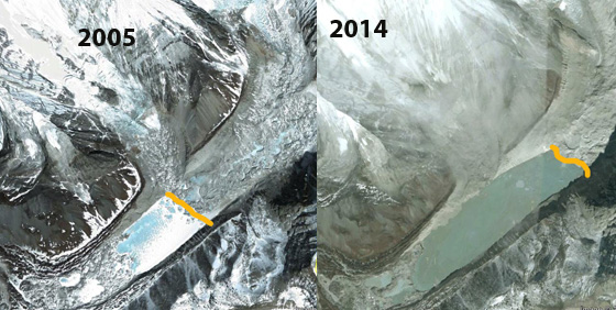
2005 and 2014 Google Earth image comparison
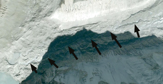
2014 Google Earth images. Black arrows indicate supraglacial stream.
 Dean of Academic Affairs at Nichols College and Professor of Environmental Science at Nichols College in Massachusetts since 1989. Glaciologist directing the North Cascade Glacier Climate Project since 1984. This project monitors the mass balance and behavior of more glaciers than any other in North America.