
April 9, 2015
Rapid Retreat of Freshfield Glacier, Alberta 1964-2014
Posted by Mauri Pelto
The Freshfield Glacier is a large glacier southeast of the Columbia Icefield in the Canadian Rockies where recent retreat has exposed a new glacier lake. Today the glacier is 9.8 km long beginning at 3070 meters and ending at 2000 m near the shore of the less than 5 year old lake. This glacier during the Little Ice Age stretched 14.3 km, one of the longest in the entire range extending beyond Freshfield Lake, which was a glacier filled basin. By 1964 the glacier had retreated 1900 meters exposing Freshfield Lake. From 1964-1986 the glacier retreated up this lake basin losing another 1200 meters of length. A comparison of a 1964 photograph from Austin Post and as close to the same view as I could get in Google Earth illustrates the 50 years of retreat. The red line halfway up the lake is the 1964 terminus and the red line at the edge of the lake the terminus location in the topographic map from the 1980’s. Here we examine Landsat images from 1986 to 2014 to further illustrate the changes. Clarke et al (2015) published this week indicates that it is likely that 70% of glacier volume in western Canada will be lost by 2100. In their Figure 4, three of the four scenarios show Freshfield Glacier as surviving to 2100. The adjacent Conway Glacier is also retreating leading to new lake formation. 
Freshfield Glacier Google Earth view

1964 image of Freshfield Glacier from Austin Post

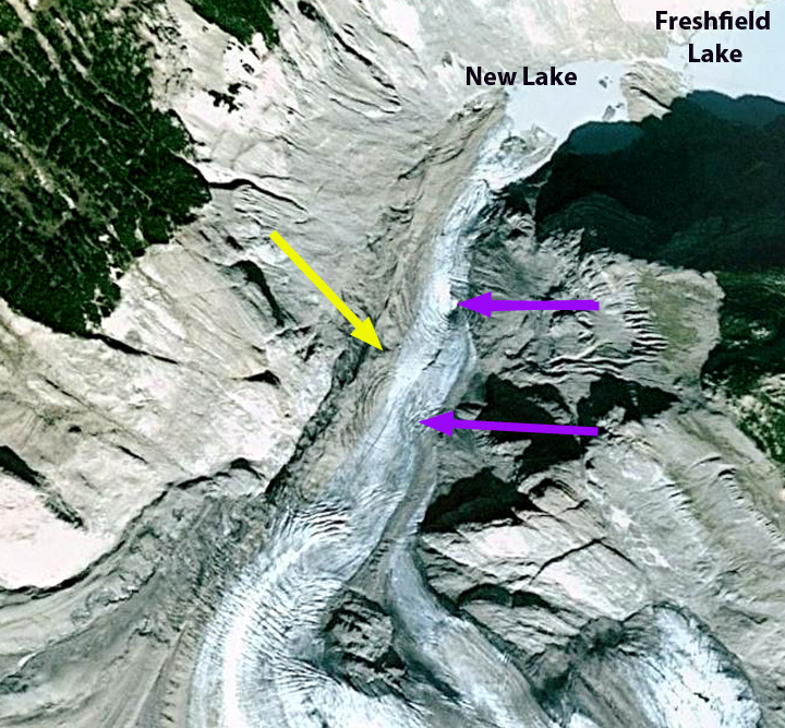
Google Earth view of Freshfield Glacier, indicating 1964, 1986 and 2014 terminus positions.
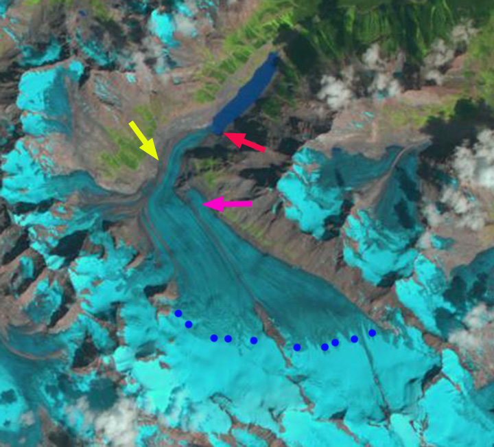
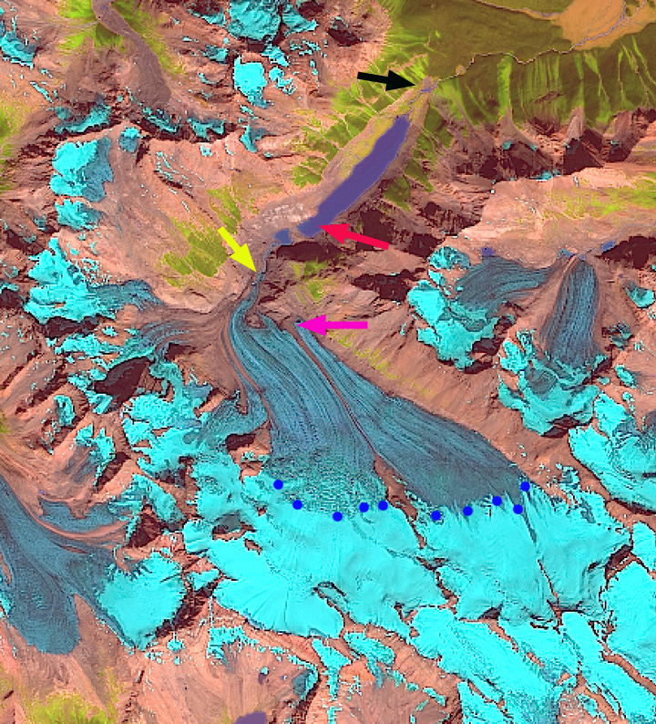
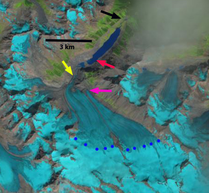
In each image the red arrow indicates the 1986 terminus position, the yellow arrow the 2014 terminus, pink arrow terminus of the eastern portion of the glacier in 2014, and blue dots the snow line on the date of the images. In 1986 the glacier still reaches the western end of Freshfield Lake, the snowline is at 2600 m and the eastern terminus reaches a bedrock step beyond the pink arrow. By 1994 the glacier had retreated to the southwest shore of the now fully formed Freshfield Lake, the snowline was between 2600 and 2700 meters. By 1998 has retreated several hundred meters from the shore of Freshfield Lake into a new basin terminating 600 m from the 1986 terminus location. The snowline is again near 2600 m. The eastern terminus has retreated from the bedrock step.
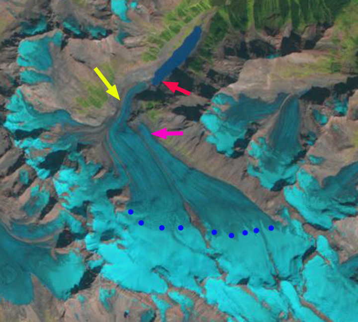
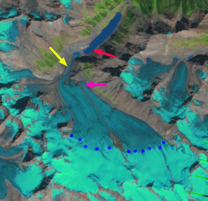
By 2009 the terminus has retreated from the basin where it terminated in 1998 exposing a new lake that is 300 m long the terminus no longer reaches. The lower 1000 meters of the glacier has a thin width suggesting the glacier terminus ice thickness is also thin. A Google Earth image from 2005 indicates two basins, circular depressions above the terminus that indicate the collapsing and stagnant nature of the lower portion of the glacier. The narrowness of the terminus reach is also evident. By 2013 the glacier has further retreated from the new lake and now ends near the base of the bedrock step. The eastern terminus has retreated to the pink arrow. The snowline in this Sept. 22, 2013 image is at 2700 m and is close to the end of the melt season position, the equilibrium line altitude. In 2014 the terminus has retreated 1700 m from the 1986 position and 2900 m from 1964. This is a rate of approximately 60 m year over a span of 50 years. The glacier remains nearly 50% snowcovered both in 2013 and 2014, indicating a persistent and consistent accumulation zone. The glacier terminus is nearing a bedrock step, with active crevassing on this step. This suggests that the retreat rate should slow in the short term. This glacier remains large and is not in danger of disappearing with present climate. Its behavior mirrors that of the Apex Glacier and Columbia Glacier but is less dramatic in terms of area loss than or the disappearing Helm Glacier. Glaciers in Alberta as a whole are losing a much greater percentage of their area than Freshfield Glacier as reported by Bolch et al (2010). 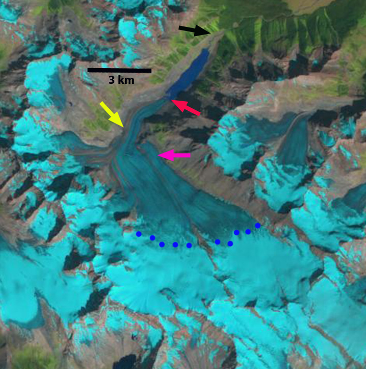
1986 Landsat image
1994 Landsat image
1998 Landsat image
2009 Landsat image
2005 Google Earth image
2013 Landsat image
2014 Landsat image
 Dean of Academic Affairs at Nichols College and Professor of Environmental Science at Nichols College in Massachusetts since 1989. Glaciologist directing the North Cascade Glacier Climate Project since 1984. This project monitors the mass balance and behavior of more glaciers than any other in North America.