
May 30, 2014
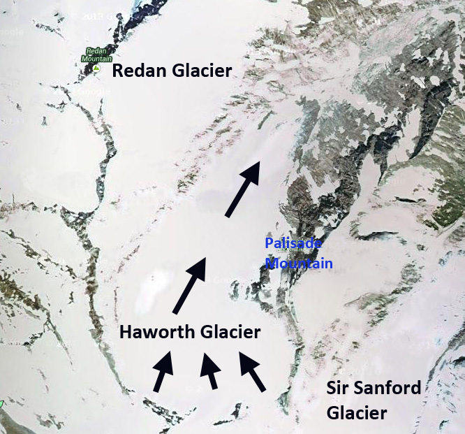
Haworth Glacier Retreat, Selkirk Mountains, British Columbia
Posted by Mauri Pelto
Haworth Glacier in the northern Selkirk Mountains of British Columbia drains into Palmer Creek, which flows into Kinbasket Lake, and then the Columbia River. This glacier is often visited by climbers as the Canadian Alpine Club has a summer base camp near the terminus of the glacier. The glacier has a low slope and limited crevassing that makes it a good training ground for climbing. Menounos et al (2008) noted an advance of this glacier overrunning a stump that has since been exposed by retreat in the period from 3800 years before present, similar in timing to many glaciers in the region. The stump remained buried until recent exposure.
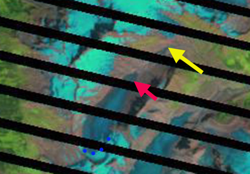
Here we examine a series of Landsat images from 1986-2013 to identify the retreat and forecast whether the glacier can survive even current climate conditions. In each image the blue dots mark the snowline, yellow arrow is the 1986 terminus and the red arrow the 2013 terminus. In 1986 the glacier ended near the far end of the basin where a lake has since developed, yellow arrow. Snowcovers 30% of the glacier in the late summer of 1986, 55-65% is necessary for glacier equilibrium. By 1994 the glacier had retreated exposing the new lake basin, the glacier was 25% snowcovered. By 1998 the glacier had retreated 550 m since 1986, the glacier was 15% snowcovered. In 2009 the glacier was 20% snowcovered. In 2013 the glacier terminates at the red arrow indicating a retreat of 1000 m since 1986, 37 m per year. The glacier is 10% snowcovered. The percent snowcover in each year is much less than the 55% minimum needed for a minimum balance, the images are also not precisely at the end of the melt season. If a glacier does not have a consistent and persistent snowcover at the end of the melt season it has no “income” and cannot survive (Pelto, 2010). This glacier has managed to retain a very small area of snowcover, but given the ongoing thinning and the lack of avalanche accumulation on this glacier, it is unlikely to be enough to save this glacier. Bolch et al (2010) noted a 10% area loss for British Columbia glaciers from 1985 to 2005, Haworth Glacier is above this average. Tennant and Menounos (2013) noted that the fastest rate of loss on Columbia Icefield glaciers from 1919-2009 was during the 2000-2009 period. The glacier is not retreating as fast as some of the glaciers that also calve into lakes such as Columbia Glacier, British Columbia. Nearby Apex Glacier has retreated at a similar rate. Jiskoot et al (2009) observed the terminus change of 176 glaciers in the Clemenceau Icefield and adjacent Chaba Icefield, and noted an average retreat of 21 meters per year from the 1980’s to 2001.
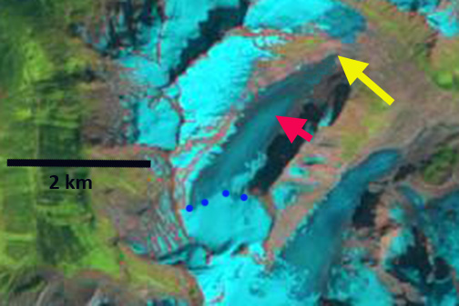
1986 Landsat image

1994 Landsat image
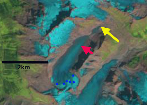
1998 Landsat image
2009 Landsat image
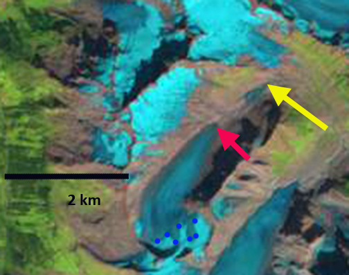
2013 Landsat image
 Dean of Academic Affairs at Nichols College and Professor of Environmental Science at Nichols College in Massachusetts since 1989. Glaciologist directing the North Cascade Glacier Climate Project since 1984. This project monitors the mass balance and behavior of more glaciers than any other in North America.