
May 21, 2013
Galaxy Glacier Rapid Retreat, Pukulkul Basin Glacier disappears, British Columbia
Posted by Mauri Pelto
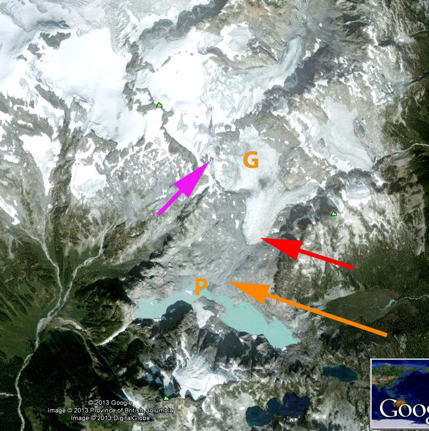
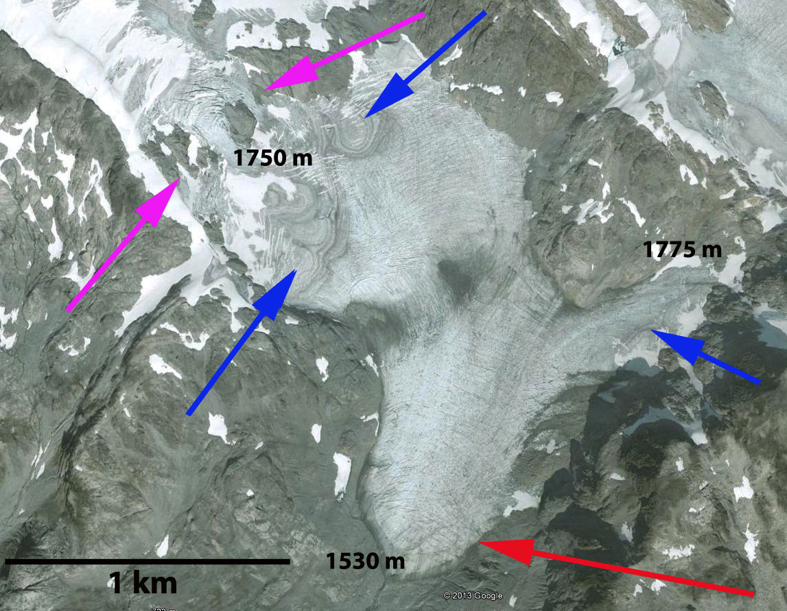
Over the ridge south from Stave Glacier is a 1.5 km long unnamed glacier, that is on the west flank of Galaxy Peak, hence referred to here as Galaxy Glacier. The glacier is in Garibaldi Provinical Park, British Columbia. 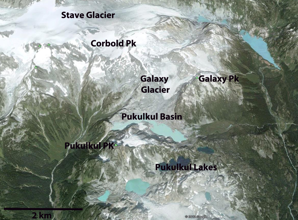 Koch et al (2009) in their detailed survey of glaciers in the park chronicled the Park’s glacier retreat from 1952 to 2002. Koch et al (2009) Found that all 45 glaciers are retreating, and Stave Glacier was experiencing its fastest retreat from 1976-1996, with a 750 m retreat. Satellite imagery from 2012 indicates the Stave Glacier retreat rate from 1996 to 2012 is 1600 m or 100 m per year, even faster. Here we utilize Landsat imagery from 1985, 1987, 1992 and 2009, plus Google Earth imagery form 2006 to examine the retreat and separation of Galaxy Glacier. The orange arrow indicates the terminus of the Galaxy Glacier (G) in 1985 where it joined the glacier (P) in the Pukulkul Basin where several lakes have been forming. This basin is just north of Pukulkul Peak. In 1985 Galaxy Glacier and the Pukulkul Basin Glacier are joined at the orange arrow, the red arrow marks the 2009 terminus and the purple arrow indicates the connection to the highest accumulation area on the east slope of Corbold Peak. By 1987 Galaxy Glacier has separated from the Pukulkul Basin Glacier, the latter has an area of 0.45 square kilometers and is larger than the lake it ends in. By 1992 the Galaxy Glacier is separated by 500 meters from Pukulkul Basin Glacier. The area of bare rock at the purple arrow at the top of Galaxy Glacier has expanded. By 2006 the Pukulkul Basin Glacier is gone and a 2.5 km long series of lakes is in its place. Galaxy Glacier has retreated 800 m from the new lake, and 650 meters from its 1985 position. The purple arrow indicates two large rock outcrops effectively ending significant glacier inflow from the upper east slopes of Corbold Peak. By 2009 the Pukulkul Basin Lake has a deeper blue as the glacier input has declined. The glacier is 90% bare of snowcover and the bedrock at the purple arrow has continued to expand. A closeup of the glacier from the 2006 Google Earth imagery indicates exposed firn layers at the blue arrows. This indicates that all the snowcover not just from the most recent winter has been lost but a number of previous winters as well. This is indicative of a glacier that has no consistent accumulation zone and cannot survive (Pelto, 2010). This glacier similar to the nearby Helm Glacier cannot survive current climate. The purple arrows indicate the limited connection to the upper slopes of Corbold Peak. The red arrow indicates the current terminus position. Galaxy Glacier has lost half of its area in the last 25 years, and the 800 m retreat is one-third of its total length.
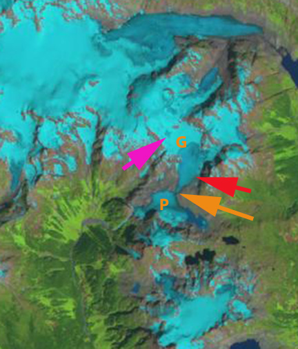
1985 Landsat
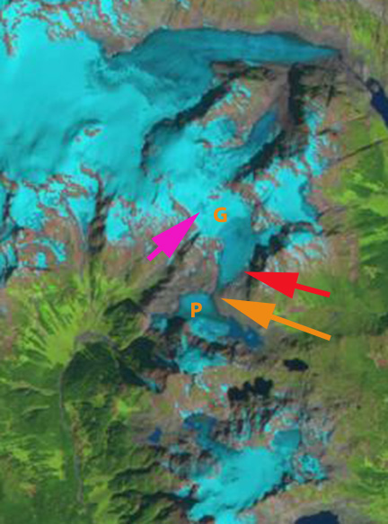
1987 Landsat
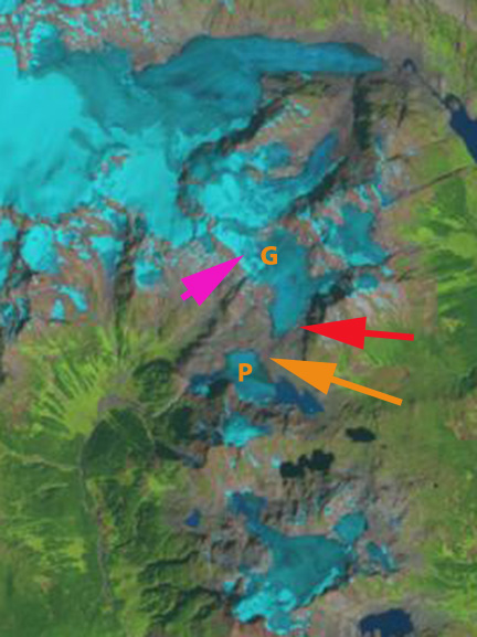
1992 Landsat
2006 Google Earth

2009 Landsat
2006 Google Earth Cloesup
 Dean of Academic Affairs at Nichols College and Professor of Environmental Science at Nichols College in Massachusetts since 1989. Glaciologist directing the North Cascade Glacier Climate Project since 1984. This project monitors the mass balance and behavior of more glaciers than any other in North America.