
March 22, 2013
Bussemand Gletscher Retreat East Greenland
Posted by Mauri Pelto
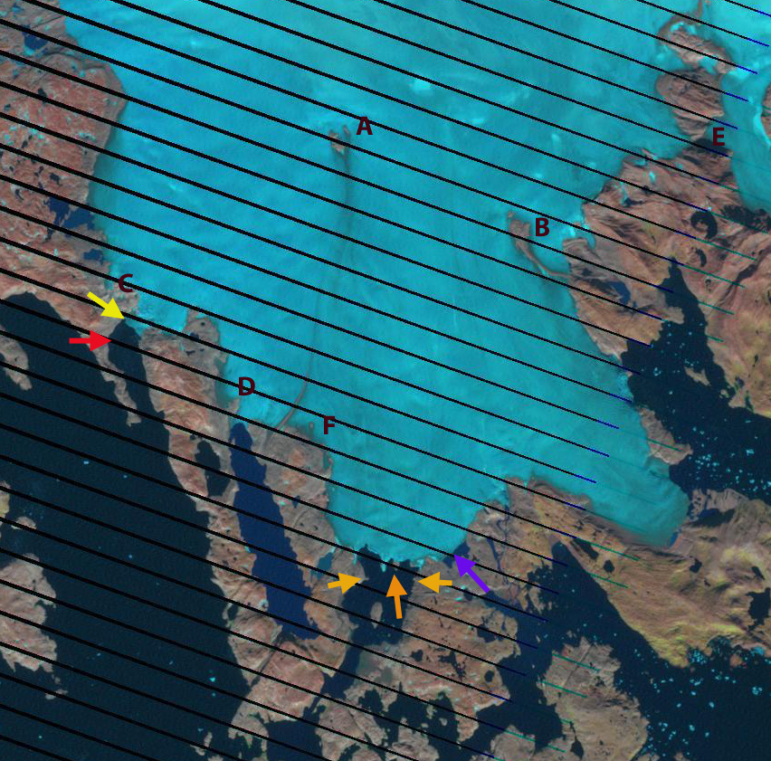
Bussemand Gletscher in East Greenland has a mixed tidewater and land based terminus. This glacier is 50 km west of Tasiilaq and just west of Nattivit Kangertivat Fjord. In this post we compare Landsat imagery from 2000 and 2012 to determine the response of this glacier to recent climate change. Espen Olsen provided the base map below and noted that Bussemand translates to bogey man. . The first two images below are a 2000 and 2012 Landsat image. On these two images the terminus in three locations is noted. The main tidewater terminus at the orange arrows is exposing a new island or peninsula as it retreats. Two orange arrows point to small prominence’s on the side of the inlet that the glacier almost reached in 2000 and has retreated 800 m from on the west side and 400 m on the east side by 2012. At the purple arrow a new proglacial lake has formed and the terminus retreated 400 m from 2000 to 2012. At the secondary tidewater terminus the glacier has retreated 700 m from the red arrow to the yellow arrow. There are also a series of letters A-F at the same location in each image each highlighting changes. Point A denotes the expansion of a nunatak within the ice. Point B indicates the expansion of a nunatak and the lateral moraine extending from the nunatak; Point C is where an area of bedrock at the margin of the western tidewater terminus has doubled in size. Point D was a small outcrop at the edge of the glacier and is now a developing peninsula. Point E was a narrow connection to the neighboring Apuseerseerpia Glacier that is now bedrock. Point F is a location where several new bedrock knobs have emerged at the surface of the glacier. Collectively they indicate the thinning of the glacier across its entire front and several kilometers inland of the front.
Below is a closeup of the terminus the two active calving embayments are indicated with blue arrows. As these narrow and the water depth drops, calving will be reduced. However, it is not clear that there is not embayment inland of this point where the proglacial lake is developing at the purple arrow. Note the channels for example between Kitak Island and the mainland in the first image. The retreat of this glacier follows that of other glaciers in the region big and small. Mernild et al (2012) noted the widespread retreat of many small glaciers including Mittivakkat. Larger glaciers were detailed by Bjork et al (2012), for example Apuserajik and Thrym.

 Dean of Academic Affairs at Nichols College and Professor of Environmental Science at Nichols College in Massachusetts since 1989. Glaciologist directing the North Cascade Glacier Climate Project since 1984. This project monitors the mass balance and behavior of more glaciers than any other in North America.