
February 11, 2013
Warwan Basin Glacier Retreat, India
Posted by Mauri Pelto
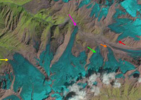
Brahmbhatt et al (2012) examine the glacier loss in Warwan and Bhut Basin’s which are sub-basins of the Chenab in India. They note a loss in glacier area from 1962 to 2001 of 19% in Warwan Basin and 9% in Bhut Basin. In this post we examine changes of several glaciers in Warwan basin, where there are 250 glaciers, from 1998 to 2011 using Landsat Imagery and Google Earth imagery. Interestingly Brahmbhatt et al (2012) note that the number of glaciers has increased since 1962, as glaciers have separated into multiple glaciers during the retreat. The glaciers are in the Marwah River Basin. Runoff from the glaciers in the basin feed the 450 MW Baglihar Hydropower Plant on the Chenab River, Jammu & Kashmir State Power Development Corp. The images from 1998, 2000, 2009 and 2011 in that order have a series of arrows indicating specific features. The pink arrow indicates the 1998 and 2000 terminus position of a glacier that reached the valley bottom and redirected the river in that valley. By 2011 this glacier retreated out of the valley bottom, a distance of 350 m, purple arrow indicates the 2011 terminus. A closeup of this terminus will be seen later. The green arrow indicates a smallrock rib amidst the glacier in 1998 and 2000. By 2009 and 2011 this rib had expanded laterally and now extended all the way to the terminus separating the glacier. The yellow arrow indicates the southern terminus tongue of a glacier that in 1998 and 2000 was nearly as prominent as the northern tongue. By 2009 the southern tongue had largely melted away, a retreat of 250 meters, in 2011 clouds obscured the location. The orange arrow indicates the terminus of a glacier that almost reached the valley bottom, turning parallel to the valley just before its terminus in 1998 and 2000. By 2009 and 2011, the terminus no longer made this turn, the width had declined and it was no longer as close to the main valley glacier. The red arrow indicates a glacier on the north side of the valley that has also retreated a few hundred meters in the last decade. The retreat of the glacier that formerly blocked the river valley reduces the potential for seasonal impoundment of the river and sudden release and downstream flooding. The Warwan Basin glaciers though smaller are experiencing the same changes as larger glaciers such as Malana Glacier and Samudra Tupa. 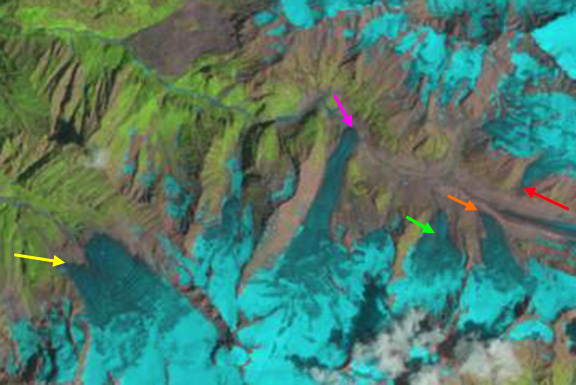


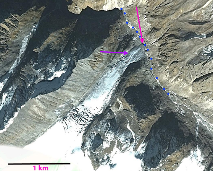
The Google Earth image is from 2002. The glacier at this time still impeded the flow of the river downvalley, blue dots. The lower 400 meters of the glacier lacks crevasses and most of this area had melted away by 2011.
 Dean of Academic Affairs at Nichols College and Professor of Environmental Science at Nichols College in Massachusetts since 1989. Glaciologist directing the North Cascade Glacier Climate Project since 1984. This project monitors the mass balance and behavior of more glaciers than any other in North America.