November 28, 2012
Dusty Glacier, Glacier Peak, WA
Posted by Mauri Pelto
In the 1990’s the North Cascade Glacier Climate Project undertook a study of all the glaciers around Glacier Peak, one century after they had been first observed by C.E. Rusk. This post focuses on one of those glaciers, Dusty Glacier on the Northeast side of the peak.
In 1940 J.B. Richardson of the Forest Service photographed many North Cascade glaciers surrounding Glacier Peak. From 1946-1958 William Long, of the Forest Service surveyed many glaciers throughout the North Cascades (Long, 1955). From 1950-1955 Richard Hubley, University of Washington, completed the first aerial glacier surveys of North Cascade termini, noting the beginning of an advance on many (Hubley, 1956). The USGS in 1960 began an annual aerial photographic survey of North Cascade glaciers that continued up through 1979. In 1984 the North Cascade Glacier Climate Project began annual terminus observations on 47 glaciers and mass balance measurements on ten of these (Pelto, 1996). The average retreat of Glacier Peak glaciers from the LIA to the 1958 positions was 1640 m. Richard Hubley noted that on Glacier Peak glaciers began to advance in the early 1950s, after 30 years of rapid retreat. The advance was in response to a sharp rise in winter precipitation and a decline in summer temperature beginning in 1944 (Hubley, 1956; Long, 1955 and 1956). Ten of the fifteen glaciers around Glacier Peak advanced, including all of the glaciers directly on the mountains slopes. Advances of Glacier Peak glaciers ranged from 15 to 480 m and culminated in 1978. All 11 Glacier Peak glaciers that advanced during the 1950-1979 period emplaced identifiable maximum advance terminal moraines. By 1984, all the Glacier Peak glaciers were again retreating. This retreat has been monitored by NCGCP. Two of the glaciers including Milk Lake Glacier and North Branch Whitechuck Glacier have disappeared.
The depth of snowpack even in Mid-August near the top of the Dusty Glacier is what drives the rapid movement and crevassing of the glacier. In the first image below the red arrow indicates the annual layer, which was 5.7 m thick in 1997. Thew second image has me standing at the terminus in 1994, which was still active even though it was retreating. 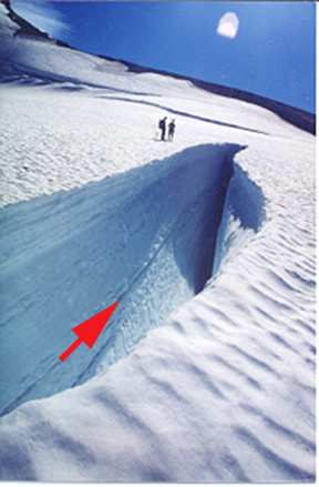

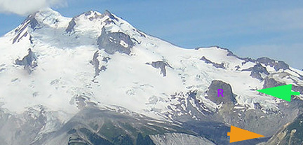
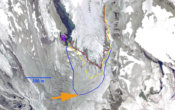
Dusty Glacier has the widest most fearsome crevasses of any glacier in the North Cascades. The glacier descends from 2750 m to 2560 m before plunging over an icefall. The glacier levels out in a basin at 2325 m, before descending a second icefall to its current terminus at 1960 m. Dusty Glacier joined with the North Guardian Glacier during the LIA, separating during the 1930’s. During the LIA the glacier advanced to 1465 m. The retreat of this glacier by 1906 when Rusk observed it had been only 400 m. The glacier ended in a basin that was filled with ice, though much of the ice was stagnant. This basin became known as Recession Basin, for the ensuing rapid retreat up until 1946 when the glacier had retreated out of the basin and ended just north of Recession Rock (R) at 2020 m. By 1955 advance was underway, an advance of 130 m had already occurred (Hubley, 1956). The advance ceased until 1967 when it began again, the glacier reaching another 150 m down into the upper part of Recession Basin at 1865 m. The terminus today is very active with extensive crevassing. In fact it is a true icefall. The glacier retreated 220 meters from its 1970’s advance moraine by 1994 during our first visit, 260 m by 1997-1998 at the time of our second visit and 400 meters by 2006 in the Google Earth imagery. The glacier remains quite crevassed though not nearly as much as in 1955. Below the first image is from 1955 taken by Richard Hubley, the second is in 2004, third in 2006 and last in 2008. In each image Recession Rock is labelled with a purple R, the maximum advance of the 1955-1970’s indicated by a orange arrow and the crevassed top of the lower icefall by a green arrow.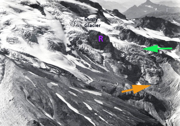


Google Earth images from 1998 and 2006 illustrate the retreat over the last 35 years. This glacier has not lost as much area as others around Glacier Peak, such as Milk Lake Glacier which disappeared, Honeycomb Glacier or Vista Glacier. The area loss has been more modest like on Suiattle and Kennedy Glacier.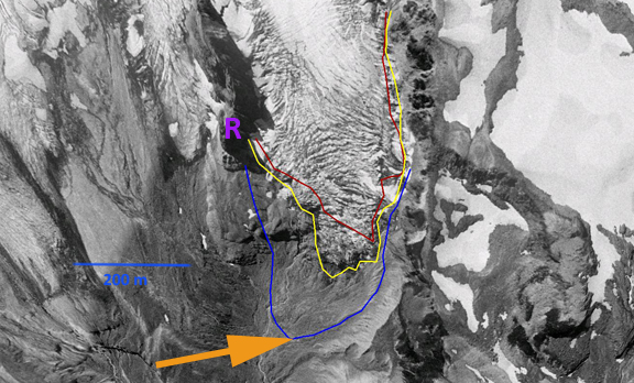


 Dean of Academic Affairs at Nichols College and Professor of Environmental Science at Nichols College in Massachusetts since 1989. Glaciologist directing the North Cascade Glacier Climate Project since 1984. This project monitors the mass balance and behavior of more glaciers than any other in North America.