
January 16, 2012
Kennedy Glacier Retreat, Glacier Peak Washington
Posted by Mauri Pelto
Kennedy Glacier drains the west side of Glacier Peak, near the headwaters of the Whitechuck River. At the turn of the century C.E. Rusk explored the glaciers around Glacier Peak that were retreating from their Little Ice Age maximum in the mid-19th century. The average retreat of Glacier Peak glaciers from the LIA to the 1958 map positions was 1640 m. From 1950-1955 Richard Hubley, University of Washington, completed the first aerial glacier surveys of North Cascade termini, noting the beginning of an advance on Glacier Peak that continued up through 1979. All ten glaciers on the slopes of Glacier Peak advanced ranged from 75 to 500 m and culminated in 1978. All 11 Glacier Peak glaciers that advanced during the 1950-1979 period emplaced identifiable maximum advance terminal moraines. A picture of the glacier from R.Luce during this advance shows a glacier with a strongly convex profile.

Kennedy Glacier (R.Luce)
During the 1993-1997 period the North Cascade Glacier Climate Project (NCGCP) surveyed the glaciers around the peak each summer, one century after C.E. Rusk did (Pelto and Hedlund, 2001). By 1984, all the Glacier Peak glaciers were again retreating. This peak even in summer provided some tough weather, including a 1995 August snow storm

Summer Snowstorm in 1975 on Glacier Peak
Two other glaciers that were a focus of this study around Glacier Peak were Milk Lake, Vista and Honeycomb Glacier.
Kennedy and Scimitar Glacier were joined during the LIA descending the Kennedy Creek valley to an elevation of 1315 m. Retreat from the LIA maximum of 1000 m had occurred by the turn of the century. By 1946 the glacier had retreated an additional 700 m to an elevation of 1960 m. In 1952 the glacier was advancing rapidly, as indicated by the 1955 photograph from Richard Hubley of the glacier from 1955. 
1955 Richard Hubley photograph of Kennedy and Scimitar Glacier (Left)
This advance continued up until 1975, the terminus having extended downslope 320 m to terminate at an altitude of 1785 m. By 1984 the terminus had begun to retreat. In 1994 the terminus had retreated 95 m and by 1997 151 m. A view of the terminus in 1994 indicates an active, crevassed terminus tongue, top image. In 1997 (below) the terminus is a well established vegetation and sediment line marking the 1970’s advance, burgundy arrows. 
Kennedy Glacier in 1994 near the terminus.

Kennedy Glacier in 1997 from Little Ice Age lateral Moraine. Red arrows indicate the moraine from advance that ended in the 1970’s. The glacier has continued to retreat, in the 1998 and 2006 Google Earth imagery the red line is the 1978 terminus, orange line the 1998 terminus and green line the 2006 terminus. Retreat from 1978-2006 averaged 225 m. The glacier is continuing too retreat, with 2015 featuring a record high snowline on the glacier. 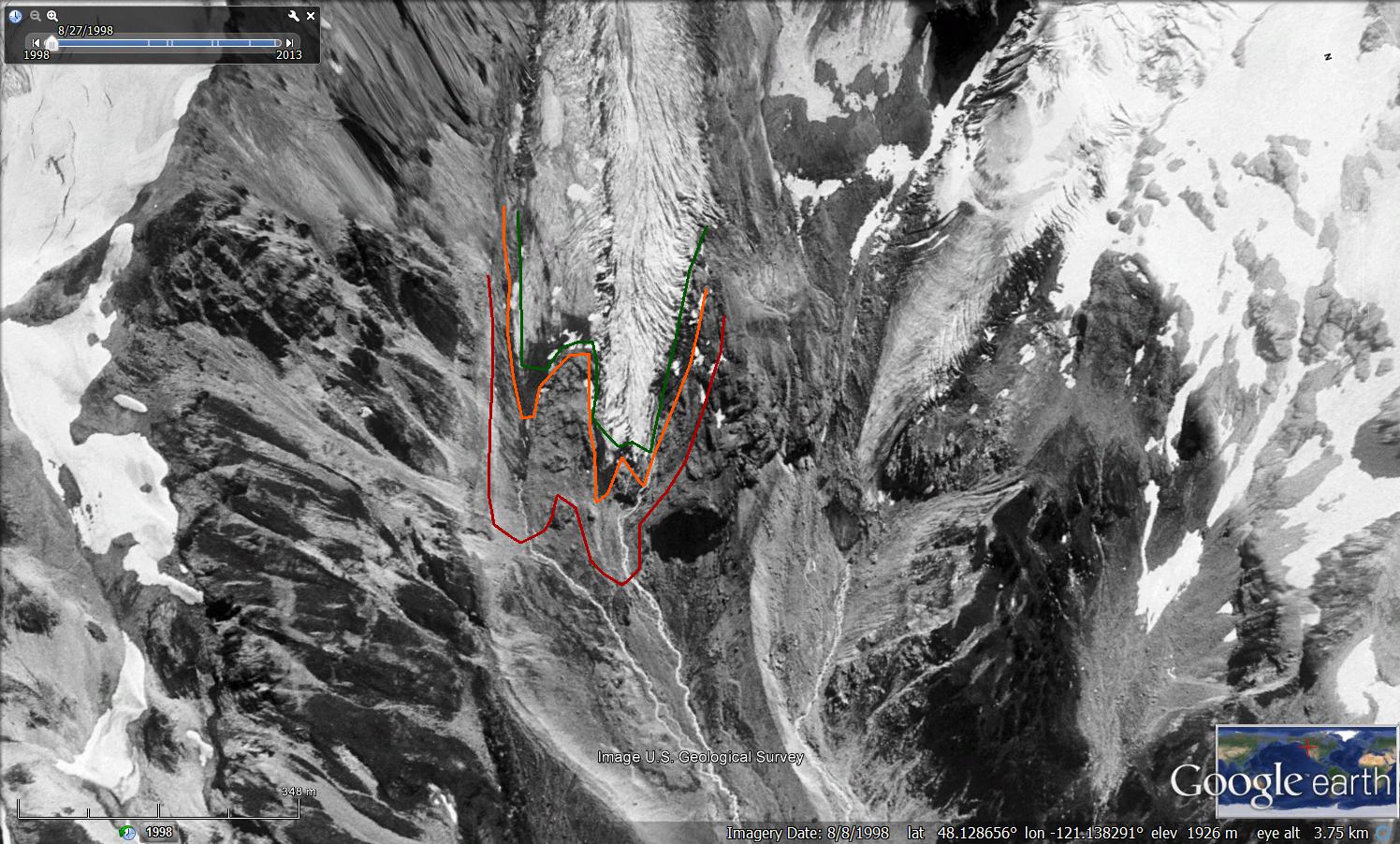
1998 Google Earth image above and 2006 Google Earth image below. Red line is 1978 terminus, orange line 1998 terminus and red line 2006 terminus.


2015 Landsat image of Glacier Peak in late September indicating the snowline at 2500 m on Kennedy Glacier (K).
 Dean of Academic Affairs at Nichols College and Professor of Environmental Science at Nichols College in Massachusetts since 1989. Glaciologist directing the North Cascade Glacier Climate Project since 1984. This project monitors the mass balance and behavior of more glaciers than any other in North America.