
March 14, 2010
Tulsequah Glacier, British Columbia Jokuhlaups and Retreat
Posted by Mauri Pelto
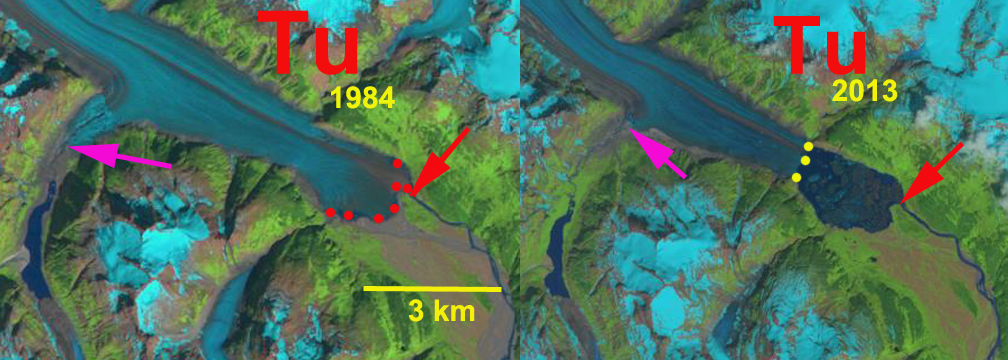
Above is a paired Landsat image from 1984 left and 2013 right indicating the 2500 m retreat during this period of Tulsequah Glacier and formation of a new lake at the terminus.
Tulsequah Glacier, British Columbia is a remote glacier draining from the Alaska-Canada boundary mountains of the Juneau Icefield. It is best known for its Jökulhlaups from lakes dammed by Tulsequah Glacier in northwestern British Columbia, Canada (Geertsema, 2000). The floods pose a hazard to the Tulsequah Chief mining further downstream. The continued retreat of the main glacier at a faster rate than its subsidiary glaciers raises the potential for an additional glacier dammed lake to form. The main terminus is disintegrating in a proglacial lake at present. Retreat from 1890-1984 had been much slower than the last thirty years. This is not unlike the situation at the Gilkey Glacier just delayed. The images below are from Google earth in 2003 and 2007 and indicate the stagnant nature of the tongue in the lake, and lateral rifting that will be points of instability for a calving disintegration.


As part of the Juneau Icefield Research Program We completed extensive snow pack measurements in the upper reach of the glacier in 1981-1984 and found that snow depths by summer’s end between 1800-2000 meters averaged 4-6 meters. These observations completed along a transect across the glacier noted in the image below, provide a good example of the different sensitivities of the glacier to global warming. In 1981 a warm winter led to minimal snowpack at lower elevations in the Juneau Region, however, the upper regions of the icefield had above average snowpack. Jabe Blumenthal and I observed snowpack of over 5 meters on the upper Tulsequah Glacier. The areas above 1500 m are not very sensitive to winter temperatures as most as precipitation will fall as snow. In 1982 Juneau had good snowpack and the upper portion of the icefield was gripped by extended cold, the minimum thermometer at Camp 8 registered -44 F.
Such cold conditions indicate continental dry climate conditions persisting. The result good snowpack low on the glacier and below normal snowpack high on the glacier. From Camp 8 Brian Hakala and I surveyed the upper Tulsequah and found 4 meters of snowpack. In 1984 the highest snowpack of 6 m was noted as Wilson Clayton and I again measured the upper Tulsequah. The glacier still had healthy accumulation. The issue driving the retreat is that the equilibrium line where melting equals accumulation and bare glacier ice is exposed has risen and is now typically at 1400 meters.
In the images below the ELA for 1984 (right) and 2006 is indicated by a black dotted line, our Camp * a green dot and our accumulation profile is an orange line. In 2006 (left) the ELA is quite high and the accumulation are not large enough for an equilibrium balance. In 1984 the ELA was lower and mass balance was positive. 

When water stored behind, on or under a glacier is released rapidly this outburst is referred to as a jökulhlaup. These outburst floods can pose a serious threat to life and property, but not from the modest floods of the Tulsequah system along this relatively undeveloped watershed. Tulsequah Glacier has a long history of often annual jökulhlaups since the early twentieth century documented by the USGS. The floods resulted after decades of downwasting and retreat of Tulsequah Glacier. In particular a tributary glacier feeding the Tulsdequah retreated and downwasted faster than the main glacier. This valley then was dammed by the main stem of the glacier. There is no surface drainage evident from either Lake No Lake or Tulsequah Lake (labelled TL and NN in image above), indicating all discharge is through a subglacial tunnel.the main stem of the glacier emerging at the terminus and causing modest downstream flooding. 
Tulsequah Lake location

Tulsequah Lake No Lake

Potential New lake
Each summer as the lake filled with meltwater, its area, level and volume would increase to the extent that the hydrostatic pressure would float the glacier enough to begin flowing, this water then would further melt the ice enlarging its conduit. Most of the release occurs within several days. Hydrologic data are used to reconstruct the times and peak discharges of floods from the glacier-dammed lakes The first jökulhlaups from Tulsequah Lake were the largest. The history of this these jökulhlaups has been declining peak and total discharges as the lake became smaller. Today, Tulsequah Lake is small, and it will disappear completely if Tulsequah Glacier retreats any further. From 1941-1971 Tulsequah Lake discharged annually. Since 1990 a Lake No Lake has been discharging annually. Lake No Lake), has formed and grown in size as Tulsequah Lake has diminished. Lake No Lake developed from a subglacial water body in a tributary valley, 7 km upglacier from Tulsequah Lake. Like Tulsequah Lake, Lake No Lake rapidly grew in area and volume during its youth, and in the 1970s it began to generate its own jökulhlaups. Lake No Lake appears to be following the same evolutionary path as Tulsequah Lake – its volume is now decreasing due to downwasting of Tulsequah Glacier, and its jökulhlaups are beginning to diminish. As Tulsequah Glacier continues to shrink in response to climatic warming, additional glacier-dammed lakes may form, renewing the cycle of outburst flood activity, the tributary where this is most likely is labeled Future New Lake in the final image.
 Dean of Academic Affairs at Nichols College and Professor of Environmental Science at Nichols College in Massachusetts since 1989. Glaciologist directing the North Cascade Glacier Climate Project since 1984. This project monitors the mass balance and behavior of more glaciers than any other in North America.