December 9, 2009
Khumbu Glacier Decay
Posted by Mauri Pelto
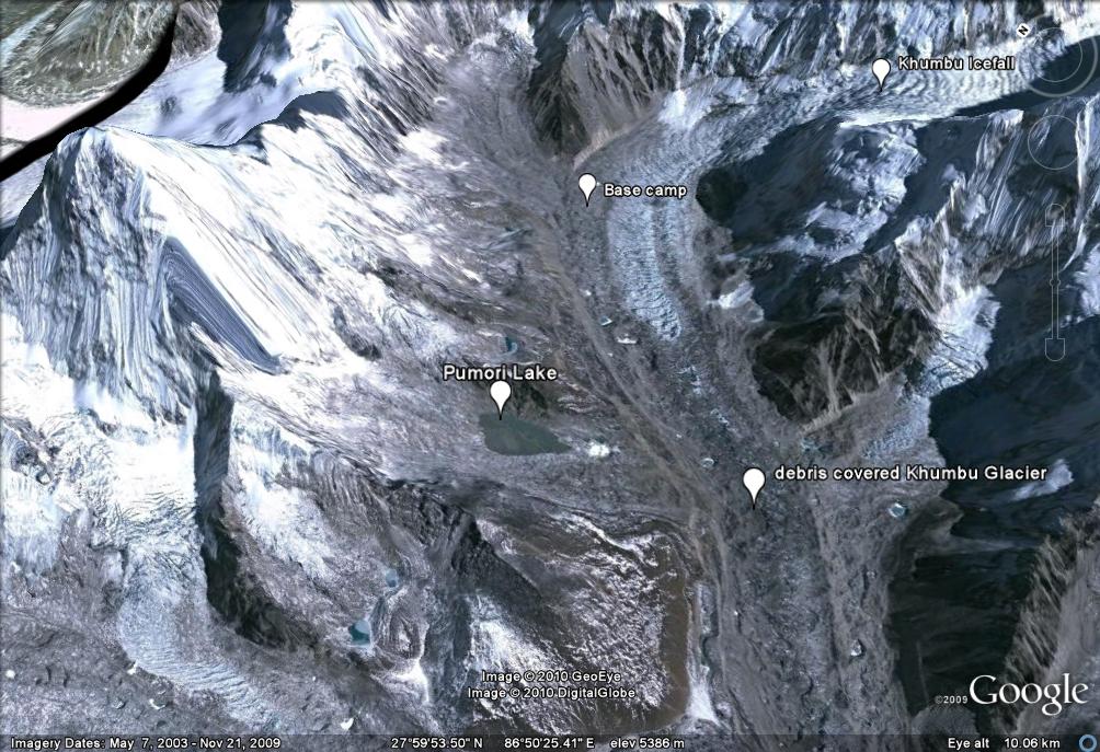
The Khumbu Glacier is a large debris-covered glacier in the Khumbu region. It is one of the more famous and often visited Himalayan glaciers as it is the key route for climbing Mount Everest. About 12 km long, it drains mainly from the West Cwm between Mt. Everest and Lhotse and ranges in altitude from over 8000 meters to 4900 m. The equilibrium line separating the region where snow typically persists through the year is 5600 m. Melting is very limited above 5800 m. The famed Khumbu Icefall transitions the glacier from the accumulation zone to the ablation zone. The ablation zone is where melting dominates. Base camp for climbing expeditions is on a debris covered portion of the glacier below the Khumbu Icefall, Pumori Lake is about one mile away. The debris cover is brought down by avalanches and exposed at the surface via melting. In the lower picture it is evident that the lower 10 km of the glacier is dominantly debris covered. 
 The Kathmandu-based mountain research institute, ICIMOD, reports that the Khumbu Glacier is retreating at an average of 20m per year. The length of the glacier has shrunk from 12,040m in the 1960s to 11,100m in 2001. This 1 kilometer retreat has been consistently between 15 and 20 m per year during this interval. This retreat is less than nearby Ngozumpa Glacier and Imja Glacier. Everest Base Camp has actually dropped from 5,320m to 5,280m since Hillary and Tenzing first set up camp there more than fifty years ago. This 40 m of thinning at the base camp has occurred over this 55 year period. Base camp is on the right side of the glacier in this view notice the small colored blotches.
Measurements of velocity on the glacier by Nakawao and others (1999) noted that the Khumbu Glacier near the climbing base camp slowed by 10% between 1958 measurements and 1995 measurements. Kadota and others (2000) surveyed the Khumbu glacier in 1995 and compared the results with those of the 1978 survey. They found that the surface of the glacier lowered about 12-15 meters over most of the length but by only 6-8 meters near the terminus. A recent paper by Bolch et al (2008) compared a Corona DTM 1962 image and the ASTER DTM 2002 of Khumbu, Glacier. During this interval the Khumbu Glacier thinned in the ablation zone by an average of 17 m, This is a rate of 0.4 m/year.
Bolch et al. (2008).
Thinning at base camp of 40 meters is greater than at the terminus. The result is a reduced glacier slope. Reduced slope and thickness both lead to deceleration. The reduced thickness loss at the terminus is due to the debris cover thickness increasing towards the terminus. The same story is playing out on the Satopanth Glacier(Image from Jeff Engels)  Takeuchi and others (2000) noted that for Khumbu Glacier debris cover less than 5 cm increases ablation, debris greater than 5 cm in thickness reduces ablation. On Khumbu Glacier their ablation measurements indicate that ablation is reduced 40% from that of clean ice when the debris cover is 10 cm thick. Thicker debris cover reduced ablation even more, but only slightly. This is the primary reason why thinning has been less near the terminus.
Naito et al. (2000) developed a model coupling mass balance and flow dynamics of debris covered glaciers and applied it to the Khumbu Glacier. The model predicts formation and enlargement of a depression in the lower ablation area about 5 km upstream of the terminus. This depression could transform into a glacier lake in future. Given the more rapid melting upglacier of the terminus and the low surface slope of this glacier, this is a reasonable result. The movement of the glacier can be tracked by examining the movement of supraglacial lakes downglacier. Below is 4 lakes denoted in a 2003 and 2009 image, the mean movement has been 120 m, 20 meters/year. 
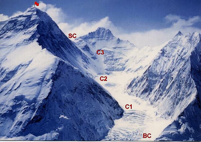
Given the slow rate of retreat and the 3000 m of altitude range above the current snowline the Khumbu Glacier is not in danger of disappearing with current climate. The entire Western Cwm the flat cirque seen beneath Nuptse, Lhotse and Everest here is in the permanent snow zone above 6000 m. The icefall then descends to 5400 m. The terminus is at 4900 m. It is not difficult to imagine this lower section of the glacier below the icefall wasting away. It is likely that a substantial proglacial will develop as is occurring at Ngozumpa Glacier and has occurred at Imja Glacier. 
Kadota, T., K. Seko, T. Aoki, S. Iwata, and S. Yamaguchi. 2000.
Shrinkage of the Khumbu Glacier, east Nepal from 1978 to
1995. IAHS Publ. 264 (Symposium at Seattle 2000 – Debris-
Covered Glaciers), 235–243.
Naito, N., M. Nakawo, T. Kadota and C.F. Raymond. 2000.
Numerical simulation of recent shrinkage of Khumbu Glacier,
Nepal Himalayas. IAHS Publ. 264 (Symposium at Seattle 2000 –
Debris-Covered Glaciers), 245–254.
Nakawo, M., H. Yabuki and A. Sakai. 1999. Characteristics of
Khumbu Glacier, Nepal Himalaya: recent changes in the debriscovered
area. Ann. Glaciol., 28, 118–122.


 Dean of Academic Affairs at Nichols College and Professor of Environmental Science at Nichols College in Massachusetts since 1989. Glaciologist directing the North Cascade Glacier Climate Project since 1984. This project monitors the mass balance and behavior of more glaciers than any other in North America.
[…] or not. Well, it is for one reason too many. The Khumbu glacier, along with the icefall. For facts, Khumbu glacier is the highest glacier in the […]
[…] it’s for one motive too many. The Khumbu glacier, together with the icefall. For details, Khumbu glacier is the very best glacier on this […]