June 30, 2009
Dramatic Retreat of Antler Glacier, Alaska
Posted by Mauri Pelto

Above is a pair of Landsat images from 1984 and 2013 indicating the 2600 m retreat of Antler Glacier in that period. Below is a detailed analysis of the glacier.
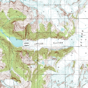
The Antler Glacier is an outlet glacier of the Juneau Icefield. It is actually a distributary glacier of the Bucher Glacier. It splits from the Bucher Glacier 8.5 km above where the Bucher Glacier joins the Gilkey Glacer as a tributary. In 1948 it spilled over the lip of the Antler River valley from the Bucher Glacier and flowed 6 kilometers downvalley to end in a proglacial lake. The glacier was 6200 m long in 1948. Note the comparison of the USGS map based on 1948 photographs and the 2005 satellite image below. 
 My only chance to see this glacier in person was in August, 1981 scouting the geology along the Bucher Glacier. Antler Glacier disappeared downvalley into the fog and light snow flurries. The terminus not in site, and icefall to daunting to wish to descend. By 2005 the glacier has retreated almost to the lip of the valley, a 5400 m retreat which is 85-90% of it total length. The Lake -Antler Lake- has expanded from a length of 1.6 km to 4.2 km. The lake is a gorgeous site, and the valley once filled by the glacier is now nearly devoid of glacier input.
  The retreat is largely a result of reduced flow from the thinning Bucher Glacier which no longer spills over the valley lip significantly. As the Bucher Glacier continues to thin, the Antler Glacier will cease to exist. This thinning is due to increased melting (ablation) of the glacier. The neighboring glaciers Field and Gilkey Glacier have also thinned and retreated considerably.


 Dean of Academic Affairs at Nichols College and Professor of Environmental Science at Nichols College in Massachusetts since 1989. Glaciologist directing the North Cascade Glacier Climate Project since 1984. This project monitors the mass balance and behavior of more glaciers than any other in North America.